What is Google Earth
Google earth is a geospatial software application that displays a virtual globe, which offers the ability to analyze and capture geographical data. January 30, 2015
What is Google Earth Pro?
Google Earth Pro extends the power of Google Earth with additional capabilities designed specifically for business users. Google Earth Pro offers the most comprehensive set of publicly available geospatial data, including high-resolution imagery, 3D cityscapes, detailed road maps, panoramic imagery at street level, historical imagery, and rich points of interest such as natural features, weather patterns, and business locations. Google Earth Pro has been available for free since 2015.
Google Earth Pro has all the easy-to-use features, and detailed imagery of Google Earth, along with advanced tools that help you measure area, radius, length and 3D buildings, print high-resolution images, import spreadsheets of addresses and instantly see mapped points with batch geocoding and create custom videos with the movie maker feature.
What are the benefits of using Google Earth Pro over other mapping applications?
It’s free, and you can create maps using other publicly available spatial data.
Key Features of Google Earth Pro
Google Earth Pro lets you fly anywhere on Earth to view satellite imagery, maps, terrain, 3D buildings, from galaxies in outer space to the canyons of the ocean. You can explore rich geographical content, save your toured places, and share with others.
Key Features include:
- See global changes with decades of historic imagery
If you’ve ever wondered how your neighbourhood has changed throughout time, Google Earth now gives you access to the past. With a simple click, check out suburban sprawl, melting ice caps, coastal erosion, and more.
- Dive beneath the surface of the ocean
In the new ocean layer, you can plunge all the way to the floor of the sea, view exclusive content from partners like BBC and National Geographic, and explore 3D shipwrecks like the Titanic.
- Track and share your paths with others
Take placemarks a step further and record a free-form tour in Google Earth Pro. Simply turn on the touring feature, press record, and see the world. You can even add a soundtrack or narration to personalize the journey.
Who can use Google Earth Pro?
Anyone can use Google Earth Pro. Just download the app to your desktop or use Google Earth Pro for android both available on the google website.
What’s the difference between Google Earth and Google Earth Pro?
There are several differences between the free version of Google Earth and Google Earth Pro, including;
- Google Earth lets you print screen resolution images, whereas Google Earth Pro offers premium high-resolution photos.
- Google Earth requires you to manually geo-locate geographic information system (GIS) images, while Google Earth Pro helps you automatically find them.
- Google Earth only allows you to import image files that are up to a max texture size, but Google Earth Pro offers Super Image Overlays that are more than the max texture size.
- Google Earth Pro uses the same imagery as Google Earth. However, Google Earth Pro offers additional tools designed for business users like the ability to create animation movies and an option to set up measuring areas of polygons or circles. Google Earth Pro also lets you map multiple points at once and enables you to access demographic, graphic and traffic data layers.
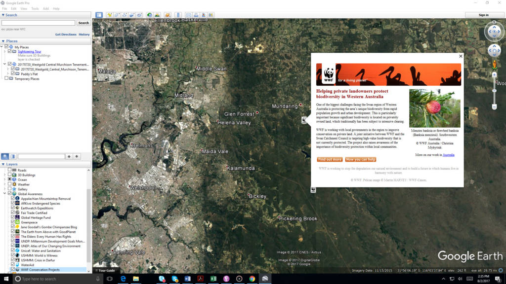
How Can Google Earth Pro and other Spatial Tools help Environmental Management?
Google Earth Pro can be used to view historical and recent imagery of places of interest, including remote areas to assist with environmental planning and rehabilitation planning including;
- Viewing historical imagery to assess areas of ground disturbance and changes in vegetation cover,
- Viewing changes in landscape (landforms, cleared areas, revegetated areas, etc.),
- Viewing proximity of sensitive areas to proposed activities/projects. Google Earth pro also has tools that can be used to easily measure distances and areas of places of interest, e.g., wetlands,
- Export data to Google maps for local syncing to make finding monitoring site in the field on a tables, and
- Importing your data or link to website data sets to create maps.
Where to go for further information.
The google support page provides some basic information on how to navigate Google Earth Pro. You can download Google Earth Pro from https://www.google.com.au/earth/download/gep/agree.html .
If you require assistance creating maps or accessing publicly available environmental spatial data give us a call (08 9466 0338) or email (enquiries@integratesustainability.com.au) or if you need more advanced training contact NGIS training at info@ngis.com.au.