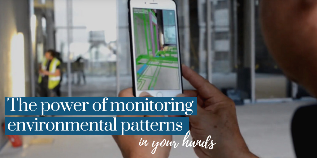
As Peter Drucker said, “If You can’t measure it, you can’t improve it”. There can be significant challenges when managing environmental changes and impacts, such as monitoring and generating reliable and real-time environmental data, so taking corrective actions to be undertaken quickly. Do you know how many new technologies have emerged and how they are contributing to making the world around us more sustainable? Have you considered that you could have the power of monitoring environmental patterns in your hand (literally)? This insight presents some ways you could use accessible technologies on your mobile phone to support environmental monitoring.
Ways to use your mobile phone for Environmental Field Monitoring
The mobile phone has been evolving rapidly. Sometimes it can be challenging to keep up to date with these changes. New technology can mean mobile phones are underutilised. One way to take advantage of technology on your mobile phone is to use it for daily field activities. For example, Depth Camera (including LiDAR sensor), Thermal Sensor and “See Through Walls – Scanner” can be built in or added onto your mobile phone to improve environmental monitoring and to acquire data quickly, accurately and practically.
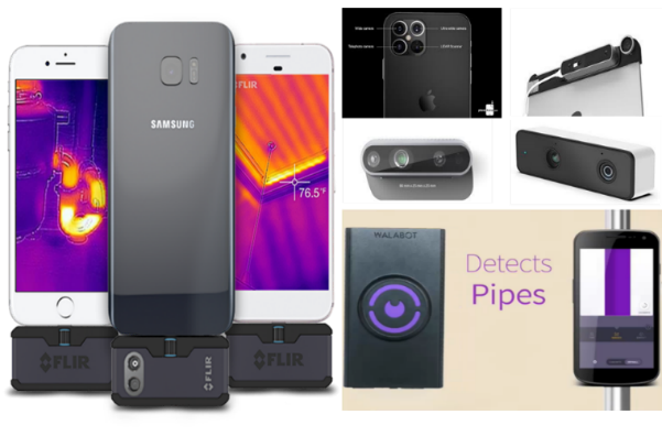
Mobiles with a Depth Camera or LiDAR sensor
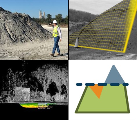
Initially, LiDAR (Laser or light detection and ranging) was used to determine the object position by measuring how quickly light or laser takes to hit something and come back again. Now, there are hundreds of applications for this technology, such as producing accurate 3D maps combined with GPS units. Some applications that you can use a depth camera on your mobile phone include to measure safety distances, measure stockpile volume, analyse terrain levelling and drainages.
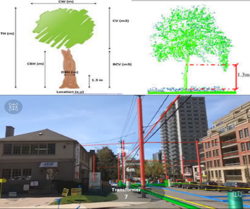
(Mónica Herrero-Huerta 2018)
Safety distance measurements: This application is based on the distance recognition measurement and is being used by architecture in cities and other environments like mine sites. Different analysis can be done to keep the environment safer for everyone; for example, you can measure:
- The tree height and canopy width;
- The safety distances between trees, streets, buildings, electrical network, gas and water pipes and other infrastructure;
- The angle measurement in slopes, downhill, and ramp embankments;
- analyse and measure waste dump slope or pit walls at mine site; and
- specific inspection of the location to help identify displacement, stress, or strain. Thus, identifying potential infrastructure subsidence or settling and other deterioration such as cracks, spalling, corrosion and damage, as shown in figure 3 (GIS Resources 2016).
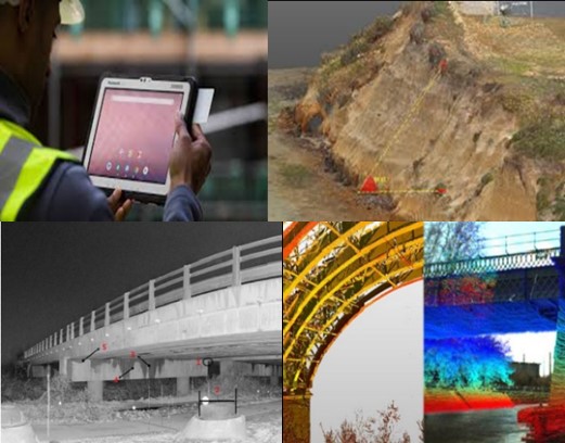
(GIS Resources 2016)
Stockpile Volume: This technology enables the measuring of stockpiled material by merely pointing a mobile phone with the Depth Camera or LiDAR sensor at the stockpiled, as shown in the adjacent image. The images are processed by software that uses an image-based and 3D reconstruction to calculate the stockpile volume accurately. Companies that need to undertake inventory management across their operations can take advantage of this new technology. Some software can process the data to measure the volume required to fill an area or to level terrain. You can use the lidar to have the real dimensions and understand where you need to move the ground to create a flat area.
Drainage: Similar to the stockpile analysis, LiDAR sensors can be used to analyse drainage. You can measure the depth parts of the terrain and check the water flow or accumulation, facilitating the measures that must be taken to manage water flow.
Thermal sensor for monitoring risks
Thermographic sensors detect infrared radiation and display images where the colours correspond to the temperature. The technology has proven to be very useful in applications such as:
- to identify hot fluids;
- heat loss in buildings;
- monitoring the function of solar and wind power plants; and
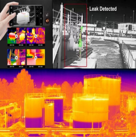
- to detect leaks and seepage (infiltration).
There are many good reasons to use a thermal imaging camera, especially to diagnose issues and ensure proper insulation. It is a cost-efficient and convenient attachment for mobile phones and can be used in different sectors, for example:
Electrical sector: to measure the electrical power transformer temperature to check if it is overloaded or has a cooling failure. It can also measure hot spots that are energy loss indicators, often contributing to poor equipment performance and efficiency;
Fuel or chemical storage: It is possible to use the thermal sensor for two purposes, for checking the safety temperature and for measuring the volume of product in the tanks without having to expose yourself to any danger. In figure 5, we can see an example of the amount of fluid in a storage tank without having to expose yourself to risks by measuring manually. In addition, we can identify leakage points and determine whether the fluid temperature can put someone at risk; and
Houses and Buildings: Thermal cameras can also contribute to the efficient management of buildings and homes. As shown in figure 6, this technology allows us to analyse the heater’s performance and also identify possible infiltration that we cannot see with the naked eye.
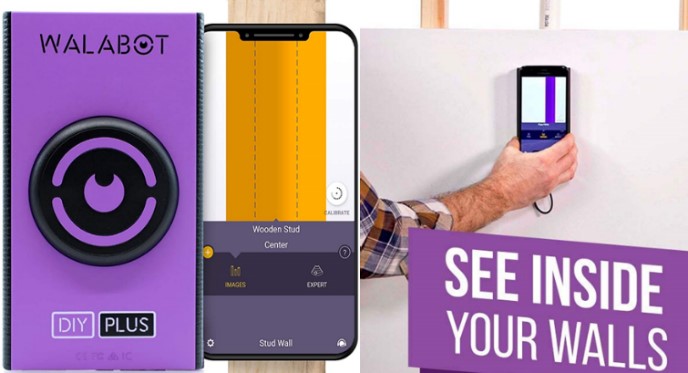
See Through Walls using the Walabot DIY Plus
Walabot DIY technology has been impressing the construction market. The “See Through Walls” scanner technology is not yet as widespread and mature as Depth Cameras, LiDAR and Thermal Sensors, but it has been promising for safety and accident prevention when drilling walls.
What can Walabot DIY detect?
Walabot is capable of “seeing” up to four inches into walls, providing users with the location of studs, stud centre, plumbing pipes, electric wires, and even movement behind the wall to help find pests (animals such as rats and mice) (Walabot 2020). Other machines can do this, but are not as convenient as carrying your mobile phone.
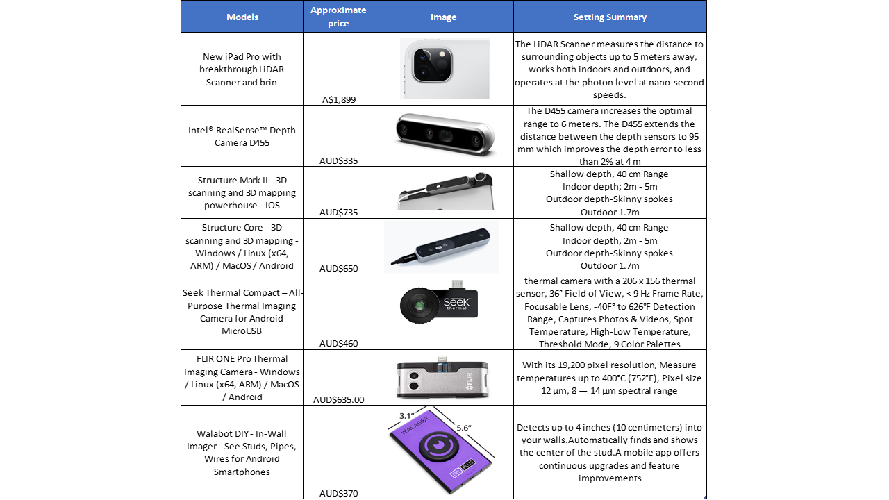
Price Summary
If you liked any of these devices to use in your company or even for your domestic activities, the price summary table below gives an idea of what equipment you need and how much this will cost.
Integrate Sustainability has experience in identifying and managing data and technology to improve environmental monitoring in WA. If you or your business needs assistance, please call Integrate Sustainability on 08 9468 0338 or email enquiries@integratesustainability.com.au.
References
FLIR. 2020. https://www.flir.com/. 08 20. Accessed 08 20, 2020. https://www.flir.com/.
GIS Resources. 2016. GIS Resources. 09 23. Accessed 08 24, 2020. https://www.gisresources.com/lidar-technology-monitoring-bridge-structure-defect-health/.
Infragauge. 2020. Infragauge. 08. Accessed 08 20, 2020. https://infragauge.com/.
Intel. 2020. intelrealsense. 08 10. Accessed 08 20, 2020. https://www.intelrealsense.com/.
Mónica Herrero-Huerta, Roderik Lindenbergh,Pablo Rodríguez-Gonzálvez. 2018. “Automatic tree parameter extraction by a Mobile LiDAR System in an urban context.” https://journals.plos.org/plosone/article?id=10.1371/journal.pone.0196004. https://doi.org/10.1371/journal.pone.0196004.
Stockpile Reports. 2020. Stockpile Reports. 08. Accessed 08 24, 2020. https://www.stockpilereports.com/.
Walabot. 2020. Walabot. 08 10. Accessed 08 20, 2020. https://walabot.com/au/diy2.
Xianhong Meng, Min Zhang *,Jiahong Wen,Shiqiang DuOrcID,Hui Xu,Luyang Wang andYan Yang. 2019. “A Simple GIS-Based Model for Urban Rainstorm Inundation Simulation.” 05 19. Accessed 08 20, 2020. doi: https://doi.org/10.3390/su11102830.