Download PDF: ISPL Insight – Remote Sensing
The representation of spatial data on maps has become an increasingly valuable instrument in environmental planning and management. Data analysis techniques have evolved from descriptive to perspective maps that display spatial relationships on a visual information platform that we all now refer to as Geographical Information Systems (GIS).
Where GIS represents powerful toolsets that are used for transforming and displaying real-world spatial data; remote sensing data retrieved by air and space located sources provides much of this valuable data for mapping and environmental management and planning.
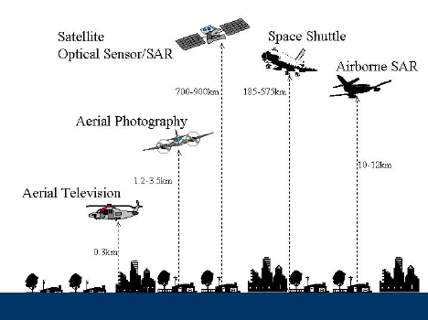
Remote sensing is the science of obtaining information about the Earth using high-flying aircraft and satellites. The data is collected by sensors attached to the aircraft that detect the energy that is reflected from Earth.
Remote sensors fall into two classifications; passive and active. In response to external stimuli, passive sensors record the natural energy emitted from the Earth’s surface. Reflected sunlight is the most common source of detected radiation. Active sensors differ in that they use internal stimuli to collect data. A common example is the use of a laser-beam remote sensing system, where data is collected by projecting a laser to the Earth’s surface and measuring the time it takes for it to be reflected back to the sensor.

Source: ResearchGate “Applications of remote sensing and GIS for damage assessment”
Remote sensing has a wide range of applications for environmental planning and management. Coastal applications, ocean applications, hazard assessments and natural resource management are just a few of the broad areas under which fall an array of analyses such as; monitoring shoreline changes, measuring ocean temperatures, tracking the impacts of natural disasters and charting wildlife habitats. These types of analyses all aid in the effective planning and management of the land and water, and its resources.
A significant area of research that is currently taking place in the remote sensing field is NASA’s Soil Moisture Active Passive (SMAP) Mission. Earth observation satellites are used to retrieve data every 2-3 days that measure soil moisture in the top 5 cm of soil over the Earth’s surface. Maximising our knowledge of the Earth’s topsoil layer is vital due to its extensive use in agriculture and supporting vegetation growth. Soil moisture also contributes to our understanding of the water cycle and forecasting weather and natural disasters for environmental management.
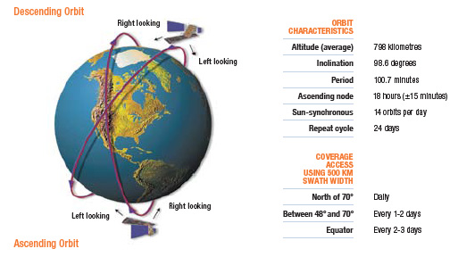
Traditionally there are two separate methods of deriving soil moisture data from space. Active sensors such as Radarsat-2 (a commercial radar satellite), which illuminates its target using an Ultra-Fine beam to detect and recognise objects and measure backscatter (the reflection of particles or waves back to the direction of the satellite). Whilst this method returns data at a high spatial resolution, it has a low accuracy. Passive sensors like the SMOS (Soil Moisture and Ocean Salinity) Mission satellite measure naturally emitted microwave radiation to record observations of sea surface salinity and soil moisture. The sensors retrieve soil moisture data from brightness temperature observations that are evident due to the large dielectric contrast between water and dry soil, where the soil emissivity ‘epsilon’ yields a particular microwave frequency depending on the moisture content it detects.

Radarsat-2 Source: Canadian Space Agency
NASA’s SMAP Mission strives to achieve the benefits of both active and passive sensors by using two instruments; a radar (active) and a radiometer (passive), to determine soil moisture content. The data observed from SMAP’s measurements will advance multiple disciplines of environmental management. In monitoring soil moisture, the SMAP provides critical information on moisture deficits for defining agricultural drought and monitoring its severity. These measurements can aid planning and management authorities in developing and implementing measures to reduce vulnerability to drought, with its predictions that can promote risk management as opposed to crisis management. The higher resolution of SMAP’s direct soil moisture measurements will also benefit the management of flooding, by assessing the wetness of soil before a rainstorm, as well as weather forecasting, by providing meteorologists with measurements on the amount of water available to be evaporated from land surfaces.
Another form of satellite data that is frequently used in environmental management, is Landsat imagery. Landsat satellites have maintained a continuous stream of data about the Earth since 1972, with Landsat 9 planned for launch into orbit in December 2020. The Landsat project ‘… represents the world’s longest continuously acquired collection of space-based moderate-resolution land remote sensing data.’ The current Landsat 8 satellite carries two sensors; the Operational Land Imager (OLI) and the Thermal InfraRed Sensor (TIRS). Orbiting the Earth every 89.9 minutes, the satellite covers the entirety of the surface every 16 days. The OLI sensor retrieves information in the form of nine spectral bands from 15 to 30 metre resolutions, whilst the TIRS retrieves Band 10 and Band 11 100 metre spectral bad data.
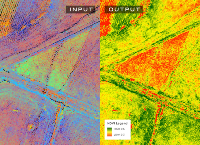
Landsat data uses range from managing and monitoring resources for both environmental and economic quality as well as public health and national security. Applications include the analysis and management of agriculture and forests, water resources, infrastructure, natural disasters, land cover change and climatic changes. The most common index used by analysts in the remote sensing field is the NDVI (Normalized Difference Vegetation Index). NDVI quantifies areas of vegetation by measuring the difference between Near-Infrared (NIR – Band 4 OLI sensor data) and red light (R – Band 3 OLI sensor data). NIR is strongly reflected by vegetation and red light is absorbed by vegetation. When calculated, NDVI values can range from the possibility of no vegetation (-1) to dense vegetation (+1). This data is heavily used in agriculture for precision farming, and in forest management to quantify leaf area indices and deforestation.

Source: GeoAwesomeness
The capabilities of remote sensing make it a valuable tool in providing decision-makers with large-area maps of target features in a quick manner, and over consistent time intervals. Environmental practitioners seeking to use remote sensing techniques have the availability of extensive data, methods and tools at their disposal. Understandably, this choice can seem overwhelming for practitioners due to the number of publications advocating new techniques and arguing ‘best’ approaches to utilising remote sensing tools and capabilities. If you or your organisation would like to discuss the most effective use of remote sensing to enhance your business capabilities, please contact Integrate Sustainability on 08 9468 0338 or enquiries@integratesustainability.com.au.
References
Droj, G 2012. ‘GIS and remote sensing in environmental management’, Journal of environmental protection and ecology, vol. 2, no. 10.
ESA 2018, ‘SMOS (Soil Moisture and Ocean Salinity) Mission’, Sharing Earth Observation Resources, ESA, accessed 20 June 2018, https://directory.eoportal.org/web/eoportal/satellite-missions/s/smos.
NASA 2018. ‘SMAP: Soil Moisture Active Passive’, Jet Propulsion Laboratory, California Institute of Technology, NASA, accessed 20 June 2018, https://smap.jpl.nasa.gov/.
NOAA 2018, ‘What is remote sensing?’, National Ocean Service, NOAA, U.S. Department of Commerce, accessed 20 June 2018, https://oceanservice.noaa.gov/facts/remotesensing.html.
Roy, D.P. Wulder, M.A. Loveland, T.R. Woodcock, C.E. Allen, R.G. Anderson, M.C. Helder, D. Irons, J.R. Johnson, D.M. Kennedy, R. Scambos, T.A. Schaaf, C.B. Schott, J.R. Sheng, Y. Vermote, E.F. Belward, A.S. Bindschadler, R. Cohen, W.B. Gao, F. Hipple, J.D. Hostert, P. Huntington, J. Justice, C.O. Kilic, A. Kovalskyy, V. Lee, Z.P. Lymburner, L. Masek, J.G. McCorkel, J. Shuai, Y. Trezza, R. Vogelmann, J. Wynne, R.H. Zhu, Z. 2014. ‘Landsat-8: Science and product vision for terrestrial global change research’, Remote Sensing of Environment, vol. 145, p 154-172, ISSN 0034-4257, DOI:10.1016/j.rse.2014.02.001, https://landsat.usgs.gov/landsat-8-mission.

